I like journaling!
-
My first journal was a diary with a key. I would like to see it again. I
think it’s in the attic, in a box, where I do not go, you know... spiders.
I mea...
My Life, Interrupted
-
I can't believe it's been one year since I've posted. Well, yes I can. What
does surprise me is that my "followers" haven't abandoned my blog! I
thought I ...
Hopefully I will have my first e-book out in December if all goes to plan. I am busy doing final edits on my first collections of short stories that will be published on Amazon and Smashwords. All have a Paris motif.
Here are some travel tips for you to use on your next trip:
Plastic is a lifesaver!
Ziploc bags are just as versatile and can even be used to keep your clothes wrinkle-free. Use them on your next trip to...
1. Keep your important documents together -- your passport and boarding pass while you’re hanging around the airport, for example.
2. Sort your currencies -- dollars in one bag, euros in another, etc...
3. Make a “kit” of all the things you want to bring on your trip but don’t need until your trip home: return trip itinerary, cab fare for the ride home, house keys, etc.
4. Keep precious items safe. Put the item you want to protect in a Ziploc bag and close it almost fully, leaving just enough open to fit a straw through. Then, inflate the bag, remove the straw, and close the Ziploc completely. Presto...self-made bubble-wrap!
5. Store your liquids or powders to prevent mess.
6. Keep your clothes wrinkle-free. Larger bags can hold rolled clothing -- which makes for neater packing and less wrinkled outfits on the other side.
7. Make a pillow. Fill a large Ziploc with cotton balls for a light and compact travel pillow.
8. Keep your luggage contents clean. Wrap your shoes in bags to prevent dirt from their soles rubbing off on other items.
(Tips from The Right Way to Travel, a favourite website of mine on how to make money out of your travels.)
Sitting on the highest sand dune in the Sahara after riding camels through the dunes to see the sunset.
Monsieur Aussie thought he was Lawrence of Arabia while we were in Morocco.
Stopping to talk to semi-nomadic Berbers in the desert was pretty special. They showed us through their tents where they live for 6 months with their animals, then they move elsewhere in winter.
We were fascinated by the oases all along the valleys. Morocco is 70% desert and most of the desert is rocky and shaly rather than sandy.
Inside the Berber tent with a new mother. The tents are lined with berber carpets of course.
More of the Sahara Desert, the Draa Valley Oasis
This is the scenery you'll see for kilometres as you drive through the Sahara Desert. The towns blend in with the red soil/sand while some of the oases go for 80 miles.
The old colonial broken down buildings from French times fascinated me. They are all over Casablanca.
I hope you enjoyed these photos of Morocco. Of course there's plenty more, but this just gives you an idea if you haven't been there. Beg if you want to see more! I have some great medina shots but I haven't downloaded them yet. Maybe I'll do another post if there's any interest in this one. I think I wouldn't mind going again now I know what to expect.
Well I've been home from my latest trip for a month or so now, but was really sick with some Parisian bug so have been slow to post anything about my holiday here. So here is the first of many posts where I will share photos of Morocco, Spain, France, Andorra. After a wonderful 9 days in Morocco, we flew from Casablanca to Paris. There's nothing like re-visiting favourite places, so after collecting our hire car at Orly Airport, we hit the road. One hour down the motorway we arrived at one of the prettiest villages in France in our opinion, La Roche Guyon, right on the border of Isle de France and Normandy. It's only a few minutes from Monet's Garden at the tiny village of Giverny which we'd vowed to revisit in summer (previously visited in winter.) It is a delight driving around this area with its picture-perfect farmlands growing apples and other produce.
Village of La Roche Guyon, all white cliffs and troglodytes. A right royal town in the past.
The wonderful restaurant at Les Bordes de Seine, the hotel we always stay. The best meals we've ever eaten in France are served here. Always full of Parisians on a day trip. Local produce is served, so we had plenty of duck and foie gras.
Sunset as seen from our hotel window overlooking La Seine. Pretty in pink.
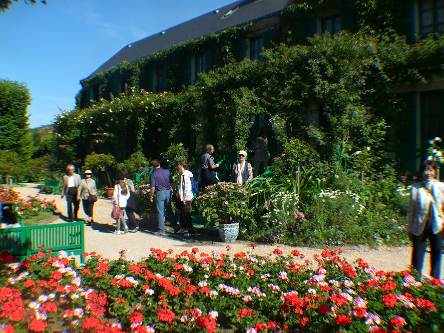
That would be moi in the centre on Monet's steps.
In Monet's Garden, which looks just like his impressionist paintings.
Posing on Monet's famous bridge which appears in many of his paintings.
The Hotel Baudy, one of the oldest buildings in Giverny. Used to be a meeting place for many famous artists, Monet included. Once a brothel, now a restaurant. We ate our very first meal here - salmon rillettes.
The bucolic Normandy countryside. A picture in summer. We saw this scene many days as we drove towards the Normandy coast to see the D-Day Beaches.
What do you think of the first couple of days of our French tour? Have you visited these villages, or Normandy?
If you have landed here, just letting you know that this blog is closed from June 09 to July 25. I am on the road again. Korea, France, Spain, Morocco, Andorra.
I have lots to do before I get on that plane, so will just be using L'Aussie Writing blog until June 17 and then checking in there from time to time. (I'm taking my netbook on my travels of course!)
When I come back I'll have lots of stories to tell and photos to share.
Hi there! Today I have posted about San Sebastian, Spain, part of our travel itinerary for June/July. I expect to be there towards the end of June. If you'd like to read a little about this beautiful town in north-east Spain, close to the French border, go here to my pichetsinparis blog.
After a day in Seoul, we head off to Paris, another 10 hours in the air eating delicious Korean food and getting spoiled by the lovely crew. We arrive at Charles de Gaulle airport in the early evening, then after fiddling around for a couple of hours, admiring the new imporved CDG airport facilites and shops, we grab our flight to Madrid. We should have found our way into mid-city Madrid by midnight, just in time for dinner! Hm, bring on the tapas!
New improved CDG airport terminal
Plaza de Espana, Madrid
San Isidro, Madrid
Bring on the tapas!
After 24-ish hours in the air (with one good sleep) we'll be a bit vague. We've done this ridiculous flight hop-around before, arriving in Dublin Ireland and asking someone what country we were in, mwhhhhhhaaaa!
Have you been to Madrid? Any advice on where to go, what to see in a couple of days before we head to San Sebastian?
As some of you know, I'm heading off for a month of travelling on 16 June to 18 July. I'm blogging about places I'm researching and visiting.
DAY ONE - BRISBANE - SEOUL, Korea (9 hours flight.)
Well this is the Seoul we are going to see. Have been here twice before for stopovers. Only there one day this time so no venturing out into the peaceful countryside where we might have seen something like this:
People may tell you Andorra’s nothing but skiing and shopping. They might add that Andorra la Vella, its capital and only town, is a fuming traffic jam bordered by palaces of consumerism. (Fact: Andorra has over 2000 shops – more than one for every 40 inhabitants). They’re right to a point, but also way off course. Shake yourself from Andorra la Vella’s tawdry embrace, take one of only three secondary roads in the state and discover some of the most dramatic scenery in all of the Pyrenees.
This minicountry wedged between France and Spain offers by far the best skiing in the Pyrenees, like in Canillo & Soldeu or Arinsal & Pal. In the last five years, its resorts have invested over €50 million in mountain cafés and restaurants, chairlifts and gondolas, car parks and snow-making machines. And once the snows have melted, summer activities are to be had in Ordino & around. There’s great walking in abundance, ranging from easy strolls to demanding day hikes in the higher, more remote reaches of the principality.
Getting there & away
Unless you trek across the mountains the only way to reach Andorra is by road from neighbouring Spain or France. If you’re driving, top up your tank when you get there; fuel in Andorra is about 20% cheaper than in Spain and a good 30% cheaper than in France.
Well here is my last post for the A - Z Challenge. I hope you've enjoyed the travel posts. Not literary enough for some I feel, but writing can be about travel too. We can therefore broaden our minds as we visit and mix with people from other lands and cultures. For those of you who have followed me on my travel blog, I hope you will continue to visit and read my posts which are usually on a weekly basis...A warm thank you to you all!!!!!!!
Deepest darkest Africa has always called explorers, traders and powerful figures who have raped this country and at times stolen its heart and soul. It has always carried a mystique from the earliest stories related in history class of Doctor Livingstone, the Victoria Falls, the Congo, the Sahara.
The Victoria Falls
One of my favourite books on Africa is Heart of Darkness by Joseph Conrad which really had an effect on me. When I saw the movie Apocolypse Now all I could think of was - another river, another time, but some things remain the same.
Geography:
Foggy morning in Harare, the capital of Zimbabwe
Size 390,580 sq km , slightly larger than Montana, US. The terrain is mostly high plateau with higher central plateau (high veld) and mountains in the east of the country. The climate is basically tropical but moderated by altitude and there is a rainy season (November to March). The lowest point in Zimbabwe is at the junction of the Runde and Save rivers at 162 m , its highest point is Inyangani at 2,592 m. Zimbabwe is a landlocked country. The Zambezi forms a natural riverine boundary with Zambia; in full flood (February-April) the massive Victoria Falls on the river forms the world's largest curtain of falling water.
Population:
African children heading to school in Harare
Just under 13 million people live in Zimbabwe. Life expectancy is around 36 years. Birth rate is on average 3.5 per woman. 25% of the population is believed to have HIV/AIDS. Literacy rate is just over 90%.
Languages:
English (official), Shona, Sindebele (the language of the Ndebele, sometimes called Ndebele) and numerous but minor tribal dialects.
Ethnic Groups:
African 98% (Shona 82%, Ndebele 14%, other 2%), mixed and Asian 1%, white less than 1%.
Religion:
Syncretic (part Christian, part indigenous beliefs) 50%, Christian 25%, indigenous beliefs 24%, Muslim and other 1%.
Political History:
The UK annexed Southern Rhodesia from the South Africa Company in 1923. A 1961 constitution was formulated that favoured whites in power. In 1965 the government unilaterally declared its independence, but the UK did not recognize the act and demanded more complete voting rights for the black African majority in the country (then called Rhodesia). UN sanctions and a guerrilla uprising finally led to free elections in 1979 and independence (as Zimbabwe) in 1980.
Tribal healers in Zimbabwe
Robert Mugabe, the nation's first prime minister, has been the country's only ruler (as president since 1987) and has dominated the country's political system since independence. His chaotic land redistribution campaign begun in 2000 caused an exodus of white farmers, crippled the economy, and ushered in widespread shortages of basic commodities. Ignoring international condemnation, Mugabe rigged the 2002 presidential election to ensure his reelection. Opposition and labor groups launched general strikes in 2003 to pressure Mugabe to retire early; security forces continued their brutal repression of regime opponents.
Economic Overview:
The government of Zimbabwe faces a wide variety of difficult economic problems as it struggles with an unsustainable fiscal deficit, an overvalued exchange rate, soaring inflation, and bare shelves. Its 1998-2002 involvement in the war in the Democratic Republic of the Congo, for example, drained hundreds of millions of dollars from the economy. Badly needed support from the IMF has been suspended because of the country's failure to meet budgetary goals. Inflation rose from an annual rate of 32% in 1998 to 133% at the end of 2004, while the exchange rate fell from 24 Zimbabwean dollars per US dollar to 6,200 in the same time period. The government's land reform program, characterized by chaos and violence, has badly damaged the commercial farming sector, the traditional source of exports and foreign exchange and the provider of 400,000 jobs.
Sunset in Zimbabwe
I know I didn't have to convince you this is a beautiful country. I've not visited yet, but anyone who goes comes back with stories of wonder.
Is Africa calling you?
My next trip is to Africa, but to the north, Morocco. I am going to see the Sahara, though.
This post is longer than usual, but you will see why. It is a mixture of personal narrative and history. Skip over it and read what interests you...
I'm not one to glorify war (even though we've just celebrated ANZAC Day in Australia and New Zealand and France and perhaps other countries too - remembering all those who died in the wars), but the Western Front, including places like Ypres, Belgium, have a special place in the hearts of Australians. So many of our young men, along with Canadians, New Zealanders, British, French, Belgae and German, lie forever in the cold earth. (Apologies if I've missed anyone out. The Americans were not yet involved.)
Poems have been written, poppies are planted and worn, memorials have been built, films have been made, books have been written, but none of this puts an end to war, which goes on and on and on so help us God.
I've always wanted to visit the War Memorials in Flanders, part of the Western Front battles. and managed it in 2008. We trained it through Germany, Luxembourg, Bruxelles (Brussels), (where we stocked up on Belgian chocolate) then onto Ypres (leper.) It was a most humbling experience to pass through these fields peppered with white crosses.
This is a view from our train window as we zoomed between Bruxells and Ypres. Get the drift?
By the time we got to Ypres, it was no longer snowing, but the day was nicely dreary as it often is in Belgium, but it was perfectly fitting to remember all the young men who fought under these horrendous conditions. Mud, gas and gunfire their last memory, along with mateship forged on the battle fields. Because the day was so bleak and no one else turned up for a tour, we were taken on a personalised tour by the Belgae guide in his 4WD. He took us to all the places the Aussies fought and lost/won/died.
Ypres — now known by its Flemish name of Ieper — is an ancient city located in the Flemish province of West Flanders.The municipality of Ieper includes the city itself and a number of villages, namely Boezinge, Brielen, Dikkebus, Elverdinge, Hollebeke, Sint-Jan, Vlamerginge, Voormezele, Zillebeke and Zuidschote. The city of Ieper and these villages counts a population of around 35,000 inhabitants.
Since the first century B.C., when the Belgae people were conquered by the Romans, the Flanders region has been invaded by successive armies and has suffered from the ravages of war. In spite of this, Ypres managed to establish itself as a financially and culturally rich city in the 12th century. By the 13th century Ypres had gained the status of an independent city-state.
Postcard of the Cloth Hall in 1914 before the war broke out. The pre-war square-topped spire of the St. Martin's cathedral can be seen on the right of the picture. It was burned during the war.
Centre of the Wool and Cloth Trade
Being only 40 miles inland from the Belgian coast, Ypres was the hub of many important trade routes consisting of roads, rivers and canals leading to the Netherlands, France and to the English Channel. Consequently it grew into an important market place for the region. Easy access to the coast meant that the the people of the city established links with the wool trade in England. The city became a very important centre for the cloth trade. Guilds and master guilds were founded. The Lakenhalle (Cloth Hall) was begun in the centre of Ypres in 1200. It took 100 years to complete. In 1241 there was a fire in the city which destroyed many of the wooden buildings. By 1260 the population of the city had grown to 40,000.
The Lille Gate (Rijselpoort) and ramparts at the southern entrance to Ypres.
Ypres grew into a wealthy and powerful city. It was the third largest city in Flanders after Gent and Bruges. It played a part in drawing up treaties and was fought over in battles. One of these battles was a siege of the city by an English bishop Henry le Despenser in the summer of 1383.
A Fortified City
From the end of the 14th century (1385) the city went into economic decline for the next two hundred years. In March 1678 the French King Louis XIV took the city into French possession, but within twenty years it passed into the control of the Spanish. The Austrian Habsburg dynasty took it over in 1713. The year of 1782 saw changes made to the fortifications by Emperor Joseph II, weakening the city defences. The French attacked the city in 1794 and once more it was under French control.
Originally the settlement had been protected by earthworks. As the town grew more wealthy the fortifications were modified to keep out prospective invaders.
Major work was carried out by Sebastien Le Prestre, Seigneur de Vauban (1633-1707), the famous French military engineer, at the end of the 17th century.
By the time of the outbreak of the First World War in August 1914 some of the fortifications had been removed. This was mainly on the northern and eastern side of the town.
The ramparts and moat looking to the north from the south-east corner of the old Ypres fortifications. Nowadays the ramparts provide a popular walking route and the moat is a haven for wildlife.
Ramparts
The oldest part of the ramparts still surviving is near the Rijselpoort (Lille Gate) which dates from 1385. After the decommissioning of the fortifications in the 1800s the remaining ramparts on the eastern and southern sides of Ypres were used until the outbreak of war in 1914 by the local people as a recreation area. The ramparts were planted with trees and paths were laid. It became a popular place to walk.
The Moat
The ramparts and moat looking to the north from the south-east corner of the old Ypres fortifications. Nowadays the ramparts provide a popular walking route and the moat is a haven for wildlife.
The moat on the east and south-east boundaries of the town. The moat was an integral part of the earlier fortifications.
When the fortifications were no longer considered necessary to keep out invaders, the new era of recreation for the townspeople in the early 1900s saw the construction of an outdoor swimming pool in the moat called the “Bassin de Natation”. It was formed at the north-eastern corner of the moat, where it was blocked off. Fishing also became a popular pastime.
Town Gates
AA feature of the fortified city was that there were gates in and out of the town. Each of the gates was on a major route from Ypres to one of the nearby four towns of Dixmuide to the north, Menen to the east and Lille to the south. The British maps and soldiers named them the Dixmuide Gate, the Menin Gate and the Lille Gate. At the Menin Gate, every evening at 8 pm, 4 buglers play the Last Post, in honour of the young men who fought in the bloody battles just outside the gate.
Just outside the Menin Gate, Ypres. (courtesty of Hellfire Corner)
When the Germans left Ypres in 1945, the plaintive notes of the Last Post rang out under the Menin Gate that same evening and have continued every evening since.
The 4 bugles ring out through the ramparts.
Ieper (Ypres) Today
Cafés and restaurants on the market square of Ypres (Ieper).
I was amazed by the way in which the medieval city has been rebuilt. My first visit was to the museum where they show footage and photos of the original Ypres, then the history of war and fire. Ypres (leper) stands almost exactly as it was prior to its destruction and it is almost impossible to believe that there was hardly a building left standing when the Great War war ended in November 1918.
Lest we forget. One of the many Commonwealth War Graves near Ypres.
In the area around Ypres - including Hill 60, Passcendaele, Lys, Sanctuary Wood etc. - over 1,700,000 soldiers on both sides were killed or wounded and an uncounted number of civilians. Read more...
I don't usually include youtube videos as they slow some people's computers down, but I'm including the trailer from the powerful film, Beneath Hill 60, which is based on the true story of the Australian miners who worked below the trenches here in Ypres. My husband and I visited this hill (several of the trenches have been preserved so tourists can see exactly how it was for the troops.) We were very excited when they made a film of it. It shows the age-old rivalry between the Brits and the Aussies with the larrakin Aussies coming out on top as usual...
Well I guess you thought I might be stumped for a place beginning with X, but straightaway Xi'an China came to mind. I've read about it's history during the terrible Japan/China wars and is a place in China that has fascinated me.
Map of Chinese cities. Xi'an practically in the centre of China.
Most of us are fairly ignorant about China, and that is partly due to its being such a closed country. It wasn't until American Presiden Nixon visited that China began to open up a little to western eyes.
Li River China
Here are the basic facts:
The People's Republic ofChina is the largest country in East Asia and the most populous in the world with over 1.3 billion people, approximately one-fifth of the world's population. It is a socialist republic (specifically a people's democratic dictatorship according to its constitution) ruled by the Communist Party of China under a single-party system, and has jurisdiction over 22 provinces, five autonomous regions:Xinjiang,Inner Mongolia,Tibet,Ningxia, and Guangxi, four municipalities:Beijing,Tianjin,Shanghai,andChongqing,and two highly autonomous Special Administrative Regions:Hong Kong and Macau. The PRC's capital isBeijing.
Tourism Xi'an
The Terracotta Army is the Terra Cotta Warriors and Horses of Qin Shi Huang the First Emperor of China. The terracotta figures, dating from 210 BC, were discovered in 1974 by some local farmers near Xi'an,Shaanxi province, China near theMausouleum of the First Qin Emperor. The figures vary in height (183 to 195 cm 6 ft to 6 ft 5in), according to their role, the tallest being the generals. The figures include warriors, chariots, horses, officials, acrobats, strongmen, and musicians.
Current estimates are that in the three pits containing the Terracotta Army there were over 8,000 soldiers, 130 chariots with 520 horses and 150 cavalry horses, the majority of which are still buried in the pits. Many archeologists believe that there are many pits still waiting to be discovered.
Bronze Horses and Cart in Shaanxi History Museum
Shaanxi History Museum, which located to the northwest of the Giant Wild Goose Pagoda in the ancient city Xi'an, in the Shaanxi province of China, is one of the first huge state museums with modern facilities in China. The museum houses over 300,000 items including murals, paintings, pottery, coins, as well as bronze, gold, and silver objects. The modern museum was built between 1983 and 2001 and its appearance recalls the architectural style of the Tang Dynasty.
Xi'an Ancient City Wall
The fortifications of Xi'an, an ancient capital of China, represent one of the oldest and best preserved Chinese city walls. Construction of the first city wall of Chang'an began in 194 BCE and lasted for four years. That wall measured 25.7 km in length, 12 to 16 m in thickness at the base. The area within the wall was ca. 36 km2. The existing wall was started by the Ming Dynasty in 1370. It encircles a much smaller city of 14 km2. The wall measures 13.7 km in circumference, 12 m in height, and 15 to 18 m in thickness at the base.
Xi'an Drum Tower
The Drum Tower of Xi'an, located in the heart of Xi'an in Shaanxi province of China, along with the Bell Tower it is a symbol of the city. Erected in 1380 during the early Ming Dynasty, it stand towering above the city center and offers incredible view of Xi'an.
Xi'an Bell Tower
The Bell Tower of Xi'an, built in 1384 during the early Ming Dynasty, is a symbol of the city of Xi'an and one of the grandest of its kind in China. The Bell Tower also contains several large bronze-cast bells from the Tang Dynasty. The tower base is square and it covers an area of 1,377 square meters. The tower is a brick and timber structure and close to 40 meters high.
I hope you enjoyed your little tour on Xi'an, China.
Have you ever been to China? Do you want to visit one day?
Well I hope you enjoyed V for Venice. This time we'll go from Old Europa to the New World. Compared to many countries, Australia and New Zealand are in their infancy as far as white settlement goes. Just over 200 years since 'civilization' arrived, and in Australia's case, declared the land 'terra nullius' - empty, ignoring the indigenous population. New Zealand's indigenous population, the Maori, have had their fight for self-determination also, but were/are more warrior-like than the Australian Aborigine. That warrior spirit lives on in the way they play their sports, especially Rugby League and Union. Those fearsome All Blacks!
The scarifying All Blacks Rugby team performing the haka before a game.
Anyway, less of the waffle. The posts for the A - Z were supposed to be short, but I figured you are all intelligent enough to flick through and read anything interesting and forget/come back later for the rest.
Why Wellington? Auckland is the capital of New Zealand isn't it? Well, yeah, but I lived in Wellington for two years, had my son there (so he's a dual citizen) and said at the time I would have been happy to live there forever. It has lovely little beaches but really doesn't have a beachy climate. Because it's the Windy City (as I hear is Chicago) the air is some of the purest in the world. I can remember holding onto the bridge rails for fear of being blown away at times. No joke.
Anyway, Wellington, NZ, here we go.
Wellington Harbour
Wellington is New Zealand's centre of government and the world's southernmost capital city. It is also the country's cultural capital and the third most populous urban area in New Zealand.
The city is home to many museums, theatres and arts festivals, including Te Papa Tongarewa (the Museum of New Zealand), the New Zealand Symphony Orchestra, the Royal New Zealand Ballet, and the biennial Festival of the Arts.
A modern city centre of the harbour
Wellington is also a leading centre for creative industries, such as film and computer technology, and it is the home of the New Zealand Stock Exchange (NZX).
The city is situated alongside Wellington Harbour and surrounded by natural beauty including Zealandia, an award-winning eco-attraction just minutes from the central business district.
The rich Maori culture is celebrated. The kapa haka is danced.
Wellington Harbour by night.
Population
Wellington city has a steadily growing population which increased by 7,800 between 2006 and 2009 to 195,500 people. The city's population accounts for 4.45% of the New Zealand population and is expected to see steady growth over the next decade. We Aussies joke that there are more New Zealanders living in Australia than New Zealand. Not quite, but Australia certainly has a high NZ populous.
Wellington city has higher proportions of Europeans (76.8%) and Asians (12.7%) than New Zealand as a whole, and lower proportions of Māori (7.4%) and Pacific peoples (6.6%).
A trip to Middle Earth anyone?
Like any city, there are many tourist attractions. One of the most populare is Welcome to Middle Earth. You knew NZ was Lord of the Rings country, didn't you? Well this is where the films were made. You can take a Middle Earth tour, visiting 9 different locations from the films (including 20+ scenes). You explore Mount Victoria Greenbelt, Wellywood suburbs, Hobbits surfing coastline and the gorgeous native forest park of Rivendell. The picnic lunch is world famous and you will go home with fantastic photos of Lord of the Rings scenes.
Your guide will take you into the heart of the Lord of the Rings, with the wealth of their knowledge, this brings the following locations to life: Hobbiton Woods, Isengard, Fords of Isen, Village of Bree, Rivendell, River Anduin, Helms Deep, Minas Tirith and Dunharrow.
The day starts with a journey through the outer shire, spending an hour walking through Wellington's greenbelt tracking the many scenes filmed there (including 'get off the road' and 'race to the ferry'). Take a drive through the South Coast to Wellywood, home to the actors whilst filming and the studios. After morning tea at the legendary Chocolate Fish Cafe (not included), drive north of Wellington to spend time amongst forests, mountains and rivers. The famous picnic lunch will be in Rivendell before you cross the swingbridge for a short native bush walk.
The tour includes a free souvenir map, elf ears for photos and a hobbit like storytelling guide for the day. Come explore Middle Earth for yourself.
Don't we all dream about our personal Utopia? Oh, you don't? It's just me dreaming about that magical place which provides us with everything we need and want. Some people find it in this lifetime, others will have to wait. I know St Paul says something like 'Whatever state you're in, be content', but I like to be content in a lot of states, but which is my Utopia?
I was first introduced to the concept of Utopia when I read James Hiltons' Shangri-la.
Let's look at - Utopia Theory in History - Shangri-la
A theoretical utopian society Shangri-la, written about by James Hilton, about the social, political, and economic structure.
Name of Utopia: SHANGRI-LA
Who Created: James Hilton (1900-1954).
Described in: Lost Horizon, published in 1933. The novel, generally neglected at the time of its first publication, was awarded the Hawthornden Prize, and soon became a classic. Two films based on the novel have been made, and the first, directed by Frank Capra, is highly regarded.
This is how Hilton's Shangri la looked:
Population: Fifty lamas reside in the lamasery that overlooks the valley where a village of nearly 1,000 Tibetans live.
Physical Layout: Shangri-La is located in a valley, surrounded by mountains, in an unexplored and nearly inaccessible region of Tibet. The utopia of the lamasery has been in existence for nearly 200 years.
Political and Social Structure: A theocracy. The lamasery and village are ruled by the High Lama, a godlike figure to all in Shangri-La. The High Lama, a French priest named Perrault, 1st arrived in Shangri-La in 1734, at the age of 53, to build a Christian monastery. Because of the air, and his development of an unnamed drug, the priest has lived for another 200 years during which time he has converted Shangri-La into a utopia where civilization might be saved from the peril of some future holocaust. Under the direction of the High Lama are 50 lamas who, like the High Lama, were lost European travelers. They spend their time in pursuit of knowledge and the arts. The political and social structure of the community is built around the word moderation, and moderation is practiced in all things--from government to love.
Property and Distribution of Goods: While the distribution of property and goods is never discussed, a rather vivid picture of the lamasery, and the valley that supports it, is provided. The valley contains a rich, fertile area 12 mi. long, and 5 mi. wide, on which a wide variety of crops is grown. There is also a rich gold deposit that provides the currency with which the lamasery buys goods are brought by native bearers who, though they never see the pass through the mountains that leads to Shangri-La, do know of a spot nearby where they are met by the village's inhabitants. Things like automobiles have never found their way to Shangri-La, but modern bathroom fixtures have. The villagers, who believe the High Lama to be a representative of God, provide for his, and the other lamas', welfare.
Production: All work is done by the Tibetan villagers, while the lamas pursue their more aesthetic ends.
Family/Marriage/Sex: Hilton offers no description of family, marriage, or sex in the village except to say that they exist, and that good manners, consideration, and moderation are the key to all 3 institutions. There are no marriages, or families in the lamasery--though love, or at least a highly platonic from of it, exists there. The one woman member of the lamasery that the novel introduces, Lo-Tsen, is described as having had many men love her, though that love has never been physically consummated. At the novel's end, however, she leaves the lamasery because of her love for someone.
Place of Women: There is at least one woman, Lo-Tsen, already at the lamasery studying to be a lama, and another is brought to Shangri-La during the course of the novel. However, their roles are never clearly defined, though it might be surmised they enjoy the same rights and privileges as men.
Education and Culture: The lamasery is dedicated to preserving and providing a home for the cultures of the East and West. To that end, the lamasery boasts a library in excess of 30,000 volumes, including Plato in Greek, Newton in English, and Nietzsche in German. New volumes are delivered periodically. The same attention paid to literature is paid to the other arts in Shangri-La, and as a result there is no sense--be it sight, hearing, or taste--that is not pleased by the environment. A former student of Chopin's, for example, resided at the lamasery and often played not only the well-known pieces of his teacher, but a large number of Chopin's unpublished works as well.
Shangri-La Station by ~Deinha1974 on deviantART
I hope you enjoyed your trip to Shangri-La. Not all wine and roses or beer and skittles, but inspiring just the same.
Map of France showing the Champagne Region with Troyes in the South-West
When I first hit France in 2004, I was on a mission to get to Italy. Sounds crazy, but Aussie travellers are crazy. After over 20 hours on a plane to reach civilization (((snicker, snicker))), we hit the road running, or speeding, whatever. So after ooing and aahing as the plane hovered over Charles de Gaulle Airport, our schedule meant we had a rugged drive ahead to get to a little hill town north of Rome. Well, why didn't we fly into Rome then? Well, there was a reason but I quite forget now!
Champagne Region. See Troyes in the South West. (We got back to Champagne in 2008 where we visited many of the other Champagne towns and drank lots of, yeah, you got it...)
Anyhoo, tiredness set in as it does when you've been in a plane for a day, so we we managed to find our way out of Paris after only one wrong turn, then found the A-whatever, and headed south. No fun navigating as night set in along with jet lag, so where to lay our weary heads? Oh, there on the map, an interesting little town, Troyes, let's investigate. (Even though our itinerary was micro-managed by our travel agent, she had forgotten to book us in anywhere on our first night!) We brought her flowers when we returned...
After driving round and round looking for the actual city, we finally hit paydirt and stumbled upon the medieval centre. Woo hoo. We like old stuff. I guarded the car while the hubs found us a room at the inn, or the Best Western whatever. Well, what do you know? Oui, oui, tres possible.
Our first night in France was spent in a hotel right in the medieval centre and the badly-maligned French staff couldn't do enough to help travel-weary Aussies - "Have another bottle of Evian, s'il vous plait." I thought they'd be tu-ing us before too long. Desole, our dining room is closed, but there is a good Chinese down the road - (((guffaw))). So our first meal in France was Chinese. Ah, such a global society! It was tres delicious so not complaining.
We staggered to bed (you know you can't get a decent wine in a Chinese restaurant, must have been all that Evian) and slept the sleep of the blissfully happy.
Ah, but next morning we really knew what happiness was! Hitting the cobblestone streets, we were blown away by the picture-postcard perfection (yes, it brings out the poet in me) of a medieval town dusted in icing sugar snow, with happy Christmas music wafting through the chilly air. Yes, Aussies also like to hit Europe at Christmas to escape the oven that is Australia at that happy time. We like to experience a 'white' Christmas once in our lives with not a prawn or a bbq in sight for once!
So, after ordering a petit dejeuner in a delightfully authentic bistro, with all these French people (((ha ha))) and little silver trays with bills, money, whatever - where's the Euros?, I was able to use my recently-revised French language skills on the uber-efficient waiter. It all worked so seamlessly that the hubs (who speaks only Strine) didn't even know I'd ordered until bowls of steaming cafe au lait and croissants came winging out way and were plonked without ceremony on the timbered table. Ah, who has tasted more delicious coffee or croissants? They tasted like nectar to a couple of starving Aussies.
Petit dejeuner over with, let's hit the streets. Bit bumpy these cobblestones and it doesn't help that they've been dusted with snow overnight, but how completely exotic! Instead of donning the bikini and hitting the waves, here we are rugged up in overcoats, boots, scarves, gloves and beanies, walking up streets of half-timbered houses which looked like they could topple any minute, all accompanied by dulcet tones of French music. Oh la la. France stole my heart that magical morning in Troyes.
Finding Troyes was just the beginning of a red-hot love affair that rages on...
Here are some of the delights of Troyes. Every time we have a rave to a French person, telling them about our Troyes' experience, they look blank. Reason? Recently found out they pronounce it Trwah and were too polite to tell us!
Here's the blurb:
Troyes (pronounced trwah), was once a center for stained glass and textiles. It was also the home of the 12th-century poet Chrétien de Troyes, who wrote versions of the Arthurian legends, and of andouillettes, sausages, made in Troyes from tripe and famous throughout France.
The many cobblestone, pedestrians-only streets in the town's historic center give Troyes an intimacy that belies its population of over 60,000. An outline of the city looks like a Champagne cork with the medieval and artisanal vestiges mostly in the St.-Jean quarter at the base, and the administrative and ecclesiastical center at the head.
Go here if you'd like to learn more abou this gorgeous place.
I am a writer, a reader and a travel junkie. When I travel, I write journals, collect bits and pieces, then use my notes to write travel articles or short fiction stories in exotic new settings.